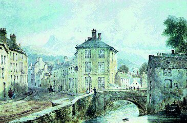
Your History: Brecon Bridges; Priory Bridge
This is one of three bridges that spanned the Honddu within the boundaries of Brecon town.They can be seen in John Speed’s map of Brecon published in 1610, and were listed by Hugh Thomas in 1698, as Priory Bridge, Castle Bridge and Aberhonddu (aka Honddu and Watergate) Bridge.
Priory Bridge crosses the Honddu at the junction of Priory Hill with the Struet.This road leads to St John the Evangelist Church, now the Cathedral for the Diocese of Swansea and Brecon.
A very old bridge, it was described as having two very clumsily built arches, the bridge itself being very narrow.The bridge now has one arch. It was probably badly damaged following the flood of 1853.
In the field above the bridge, once stood a thriving Woolen mill.This can be seen in the 19th century painting by John Murray Ince, above. The Honddu river accommodated several Mills.
Priory Hill and the bridge have always carried a great deal of traffic. It is the direct route from north Breconshire, including Epynt and Builth traffic as well as the farms and villages en route. It would also have been the main droving route from north Breconshire and further afield.
© Breconshire Local & Family History Society


